Spatially mapping soil and landscape properties
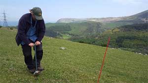
Fig. 1 Taking soil cores on the semi-improved field site.
Soil and landscape properties which potentially influence nitrous oxide emissions from soil are being collected and mapped in GIS. Examples of soil properties that have been measured include bulk density, water content, pH, electrical conductivity, mineral N, organic matter and total nitrogen and carbon contents. Soil cores are collected (Fig. 1) on a gridded basis across the field sites. Other landscape properties that are being mapped include topography, and vegetation composition using multispectral imaging.